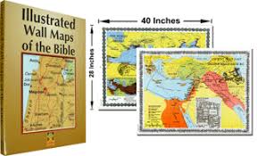
This beautiful resource is the perfect choice for Sunday School, college classes, or any sort of Bible class. The size of these wall maps (28 X 40 inches) is ideal. The maps themselves are attractive and loaded with the best information. Carta maps are my favorite and the ones chosen for this package are the most important for a teaching setting.
When you open the container that holds these maps you will first see an 18-page Bible atlas that will aid your use of the larger maps and help you prepare to teach. All 12 maps are included in this atlas along with 5 additional maps. The bonus maps in this atlas include: The Land of Canaan with an inset of the walls of Jericho, The World of the Greeks with a small insert of the empire of Alexander the Great, The Roman Empire with a small inset of the city of Rome, Jesus in Galilee (an exceedingly helpful map), and the Growth of Christianity. Don’t miss the chronological table on the back cover either. All of these will give you a leg up as you use the large wall maps in the classroom.
The first wall map, Culture and Commerce in the Ancient Near East, provides a helpful overview of the ANE and why population centers gravitated to where they did. The second map, ANE in the Second Millennium B.C., helps you see that Israel falls between the dominant areas of Egypt and the peoples near the Tigris and Euphrates Rivers. In that millennium Egypt was the more dominant. The map that covers the next millennium shows the ascendency of the Arameans and Babylonians.
A map on the Coming of the Israelites narrows the focus to Israel and includes an inset of the Exodus. The next two maps cover respectively the Kingdoms of David and Solomon and the Kingdoms of Judah and Israel after the Kingdom split. The insets include a map of Megiddo and Jerusalem in the 6th Century B.C.
Next, the maps turn to the New Testament with the first one showing Palestine in Greco-Roman Times with an inset of Jerusalem in the Hasmonean period. The next map, Jesus In His Land, shows some of the broad sweeps of Christ’s life and the inset brings Jerusalem to Christ’s time as well. A map called The Journeys of the Apostles shows from Israel to Tarsus and covers Philip and Paul’s work there. The inset shows Caesarea Maritima. The next map, the Spread of the Early Church, views Christianity from Babylon to Rome and to Egypt to the south with an inset of Paul’s Missionary Journeys. I might have swapped the map and the inset there, but both are good. The final two maps show physical maps of Israel with wonderful detail and many place names for each Testament respectively.
I’d easily label this the best set of wall maps I’ve ever encountered. This collection a winner!
I received this book free from the publisher. I was not required to write a positive review. The opinions I have expressed are my own. I am disclosing this in accordance with the Federal Trade Commission’s 16 CFR, Part 255.